Winds swirled late into storm
Published 1:45 pm Sunday, August 28, 2011

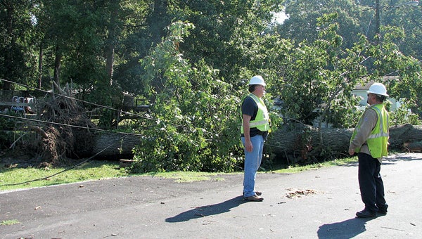
Power company workers evaluate the scene of a tree down on power lines on Johom Lane off Wilroy Road. The storm brought down numerous trees around the city, knocking out power to a majority of Suffolk customers and blocking a number of roads. Irene’s fury stretched from North Carolina to New England and caused several deaths, including that of a young boy in Newport News.
The storm appeared to be over — and then the wind came.
Hurricane Irene dumped more than 10 inches of rain on Suffolk and brought wind gusts upwards of 60 miles an hour to the city.
But the strongest winds came late Saturday night, when most people thought the worst was over.
“That really wasn’t something that normally happens,” said Bill Sammler, a meteorologist with the National Weather Service office in Wakefield.
Sammler said the winds higher up in the storm were able to come down to the surface, creating the highest winds of the storm when many thought it was almost over.
“That created a little bit of an unusual situation,” Sammler said.
Wind and rain gauges at the Suffolk Executive Airport failed Saturday night, but the rain gauge measured about 10.7 inches at 9 p.m.
“It may be a little higher than that,” Sammler said of the final rainfall total.
The rain and wind toppled trees and flooded numerous streets throughout Suffolk. North Main Street was closed at the Kimberly area, where the Nansemond River frequently swells during major rain events.
However, the flooding there was gone Sunday morning and not expected to return, Sammler said.
“That’s a tidal river,” Sammler said of the Nansemond. “The issue from rainfall will go away once the tidal flooding from a nor’easter or tropical storm like Irene passes.”
But flooding still is a concern west of Suffolk, particularly along the Blackwater and Nottoway rivers. They are expected to crest at about 20 to 21 feet on Monday night.
However, Sammler said, they will be lower than the flooding that occurred after Hurricane Floyd in 1999. The flooding from Floyd devastated the downtown Franklin area, inundating most businesses.
Suffolk city crews hit the streets early Sunday, evaluating roadway and drainage conditions and clearing debris from roads.
Dominion Virginia Power’s first priority on Sunday was responding to emergency calls, such as lines down, and restoring power to critical infrastructure like hospitals, police and fire stations and water treatment facilities.
“Those are our number one priority,” said Bonita Harris, a spokeswoman for Dominion. “As soon as daybreak hit, we had patrollers out there assessing damages.”
Crews have come from Alabama, Georgia, Kentucky and Ohio, among other places, to provide mutual aid assistance in getting power restored. Dominion’s response to Hurricane Irene will be second in scale only to 2003’s Hurricane Isabel, Harris said.
She said the company plans to tell customers by Monday when they can expect to get power back. On Sunday morning, about 24,500 customers in the Suffolk area were without electricity.
She urged people to be patient and to follow safety precautions when using generators, such as making sure they are well-ventilated.
Harris also reminded drivers to beware of power company workers doing repair work.
On Sunday morning, there was not yet any word on whether the hurricane was able to extinguish the wildfire in the Great Dismal Swamp National Wildlife Refuge — an outcome seen by many as a silver lining to the clouds.


