East Coast braces for ‘catastrophic impacts’
Published 8:56 am Sunday, October 28, 2012
From AccuWeather.com
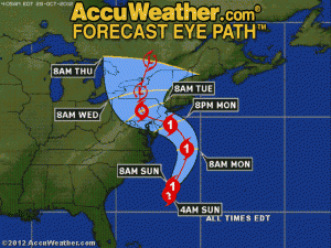
AccuWeather.com reports that Hurricane Sandy remains on track to become a historical storm with communities from Norfolk to Boston bracing for catastrophic impacts.
The worst of Sandy will hit the area Monday through Tuesday, but the Southeast coast is already feeling the effects of the hurricane, according to meteorologists from AccuWeather.com.
AccuWeather.com updates on Sandy:
Sunday, Oct. 28
6 a.m.: Sandy is a truly massive storm on satellite. It is one of, if not the largest tropical cyclones to ever develop in the Atlantic basin.
5 a.m.: Sandy holds serve. Still a hurricane. Headed on a crash course with New Jersey.
4 a.m.: Rainfall from Sandy reaches Philadelphia.
2 a.m.: Sandy is still a hurricane with winds at 75 mph. Pressure hovering around 960mb.
Saturday, Oct. 27
11 p.m.: Repeated 54-mph gusts at the Alligator River bridge in far eastern North Carolina.
8:29 p.m.: Ferry service to Ocracoke, N.C., was suspended, and people are reported stranded.
7:52 p.m.: Rodanthe, N.C., on Hatteras Island is already experiencing ocean overwash.
7:29 p.m.: Delaware declared a state of emergency and has begun limited mandatory evacuations in preparation for Sandy’s approach.
6:58 p.m.: Amtrak is canceling some service for Sunday. Routes in Virginia, Washington, D.C., and New York are affected, according to the Amtrak Facebook page.
6:16 p.m.: Ferry service for Cherry Point, N.C., has been suspended, according to a spotter.
6 p.m.: New York Mayor Bloomberg spoke during a press conference at 6 p.m. EDT Saturday. He said, “We will make an announcement tomorrow in the middle of the day on whether or not to close mass transit.” Bloomberg also said that people needing public transportation should travel to their destinations by 7 p.m. EDT Sunday.
5:36 p.m.: A local emergency manager in North Carolina reported a tree down and blocking one lane of a road near Bolivia.
5 p.m.: The center of Hurricane Sandy with maximum sustained winds of 75 mph was located about 335 miles east-southeast of Charleston, S.C.
4 p.m.: Winds over 40 mph are hitting the North Carolina coast along with heavy rains. Radar shows high winds spreading across the North Carolina coast.
3 p.m.: A Computer model that was showing a farther south track into the Delmarva is now bringing Sandy into central New Jersey, lining up with the AccuWeather.com Hurricane Center’s track.
2:03 p.m.: Hurricane Sandy recently produced a wind gust of 76 mph (Category 1 hurricane force) about 140 miles east of Cape Canaveral, Fla.
1:46 p.m.: AccuWeather.com Senior Meteorologist Brett Anderson stated, “Strongest winds headed to the corridor from Baltimore to Philadelphia to New York City will be coming in from the north-northwest to east direction; keep that in mind when parking your car near large trees.”
12:40 p.m.: Tropical storm-force wind gusts reach the North Carolina coast. Highest wind gust reported so far today was 40 mph at Cherry Point, N.C.
12:25 p.m.: AccuWeather.com meteorologists just held a discussion on Hurricane Sandy and have pinned down its landfall site to central or southern New Jersey Monday evening. However, it should be stressed that the worst of the storm will occur ahead of its center.
11:20 a.m.: The wind field of Hurricane Sandy is extremely large with tropical storm-force winds extending 450 miles away from its center.
11 a.m.: Sandy has changed little in strength in the past three hours with maximum sustained winds of 75 mph. The center of Sandy is located about 355 miles southeast of Charleston, S.C.
9:57 a.m.: Evidence that Hurricane Sandy is a large storm: Charleston, S.C., and Bermuda are seeing from Sandy despite being separated by 900 miles.
9:30 a.m.: AccuWeather.com meteorologists are now concerned that all of Delaware, southern New Jersey and southeastern Pennsylvania — including Philadelphia — will be inundated with more than eight inches of rain from Sandy.
8 a.m.: Sandy regains hurricane strength after weakening briefly to a tropical storm.


