Round and round it snows
Published 1:23 pm Tuesday, January 28, 2014
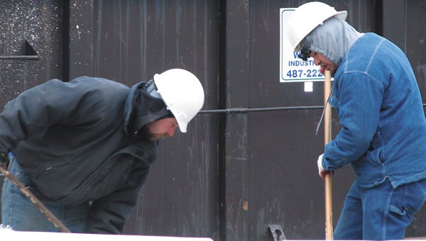
Donald Perkins and Claudio Esbarza are bundled against the 13-degree wind chill on Tuesday as they clean up a construction site on West Washington Street.
Cold arctic air and a coastal low-pressure system have combined to give the Hampton Roads area several inches of snow.
“Because of the cold air in place and the additional moisture, we’re actually going to get a good shot of snow,” said Bridget DeRosa, a meteorologist with the National Weather Service in Wakefield.
Accumulation ranging from 6 to 8 inches was due for the Suffolk area, she said Tuesday morning before the onset of the snow.
An inch or two was expected to build up by Tuesday evening, with the onset a little later than first expected, DeRosa said.
“We’re pretty dry right now, so it’s going to take quite a bit to overcome that,” she said Tuesday morning.
The rest of the accumulation was expected to be on the ground by Wednesday at daybreak, with snowfall tapering off after that.
For anybody who has to go to work Wednesday, the commute will be a challenge, she said.
“The roads will be snow-covered with some slick spots,” she said. “As the tires compress the snow, it will create some icy patches, especially on untreated surfaces.”
Officials urged people to stay home Wednesday if at all possible or to make sure their cars are stocked with food and water if they have to venture out.
City spokeswoman Diana Klink said crews had begun pre-treating bridges and overpasses, on- and off-ramps and Route 58 with a brine solution on Tuesday morning. Employees are set for 12-hour shifts and will switch to plows and put down abrasives once accumulation begins.
“It’s considered light, fluffy snow, which tends to accumulate more rapidly,” making the situation more treacherous, Klink said.
Temperatures through Wednesday night are expected to stay pretty much the same, with a high on Wednesday in the mid to upper 20s. A high pressure system then will initiate a gradual warm-up that will culminate in highs in the 50s this weekend.
“At least we finally get a little bit of a break,” DeRosa said.
While you’re out playing in the snow, be sure to snap some photos and send them to news@suffolknewsherald.com. Identify the photographer and the people in the photos, and you could see them in Thursday’s paper or online at the Suffolk News-Herald’s Facebook site. Watch www.suffolknewsherald.com on Wednesday for continuing updates on closures and cancellations.