Joaquin strengthens, tracks east
Published 10:43 pm Thursday, October 1, 2015
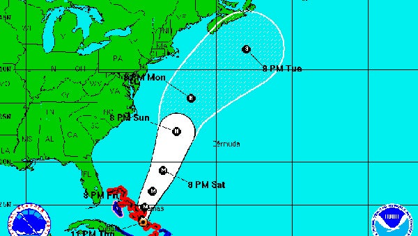
Models show Hurricane Joaquin continuing to track away from the East Coast.
Hurricane Joaquin strengthened to a Category 4 storm on Thursday, but its projected track turned slightly eastward, reducing the likelihood that it would deal much more than an indirect blow to Southeast Virginia and Northeast North Carolina.
But even with the storm’s shift in direction, Virginia officials were warning of the potential for damaging flooding and winds coming from a separate storm pattern that has swept across the state this week.
“We have a major weather pattern,” Gov. Terry McAuliffe said during a news conference Thursday afternoon. “We will have flooding. We will see trees down. We will have power lost.”
Flooding already has been seen in the western part of the state, McAuliffe said, including nine roads washed away and 57 roads still closed.
“We do expect travel to become hazardous,” said Brian Moran, secretary of public safety and homeland security. “The main thing is to be safe and watch the ponding on the roadways.”
At 9 p.m. Thursday, Suffolk was under a coastal flood warning until 6 p.m. Friday and a flood watch until 8 p.m. Saturday.
Rainfall amounts of four to seven inches are expected through Saturday. Ponding on roadways and flooding of low-lying and poor drainage areas is likely, especially where the ground is saturated, according to the National Weather Service. Stream and river levels also are expected to rise.
Thursday evening, the weather service was reporting Joaquin was located about 25 miles east-southeast of Clarence Town Long Island and 75 miles south of San Salvador in the Bahamas, moving west-southwest at 5 miles per hour. The storm was packing maximum sustained winds of 130 miles per hour.
Joaquin quickly strengthened throughout the day on Wednesday, and meteorologists were calling it a “large” hurricane, with hurricane-force winds extending up to 50 miles from its center and tropical storm-force winds extending outward up to 185 miles.
They predicted a turn to the north on Friday and then faster motion to the north on Friday and Saturday.
With Joaquin’s turn toward the east, the five-day forecast cone now just grazes the Outer Banks of North Carolina and Hampton Roads. Current predictions have the eye passing Virginia’s coast on Monday.
The coastal flood watch in effect for much of the Mid-Atlantic owes as much to the heavy rains associated with a low pressure system making its way east as to the impending hurricane.
Rain will drench Suffolk and surrounding areas throughout the weekend with or without Hurricane Joaquin, National Weather Service meteorologist Bill Sammler said.
About 800 National Guard soldiers have been mobilized and will be pre-positioned across the state by the end of Friday.
State officials said large-scale evacuations of coastal areas for Hurricane Joaquin are not planned, because the western areas of the state already are flooded.