Remnants of Ian dumps rain on region, localized flooding and road closures reported in Suffolk
Published 2:00 pm Friday, September 30, 2022
|
Getting your Trinity Audio player ready...
|
Editor’s note: This story was updated at 3:01 p.m. today to reflect landfall of Hurricane Ian and to correct expected rainfall levels for the Suffolk area. Story was then updated at 3:19 p.m. to reflect a road closure due to flooding.
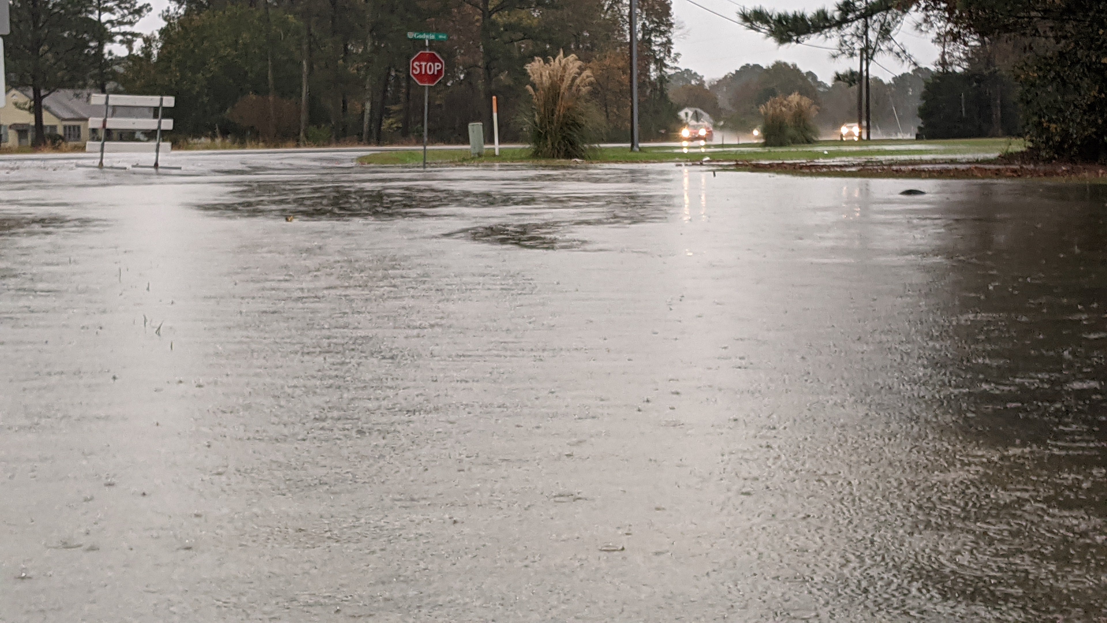
Suffolk and the Western Tidewater region are expected to get up to four inches of rain through Saturday as the remnants of the powerful Hurricane Ian push through the region.
The National Weather Service’s Wakefield office forecasted three to four inches of rain Friday for Suffolk, and another one to two inches to fall Saturday.
Ian, which first made landfall as a near-Category 5 hurricane in southwest Florida near Cape Coral, made landfall in Georgetown, S.C. just after 2 p.m. Friday afternoon as a Category 1 hurricane with winds of 85 miles an hour. It is now expected to move northwest and weaken over the Carolinas Saturday.
Various watches and warnings have been issued for Suffolk and the Western Tidewater and Hampton Roads regions.
The City of Suffolk announced this afternoon that North Main Street is currently closed in both directions in the 700 block near Kimberly Bridge due to tidal flooding. Detour signage has been placed in the area. City officials said motorists are reminded to exercise extreme caution when driving in flood conditions, especially this evening when darkness falls and it may be more difficult to see areas of flooding.
A flood watch is in effect for all of Western Tidewater and Hampton Roads from Friday morning through Saturday morning, meaning flooding caused by excessive rainfall is possible. A coastal flood warning was also in effect beginning at 11 a.m. Friday through 8 a.m. Saturday for Suffolk, Surry County and Isle of Wight County. It means around two feet of inundation above ground level is possible in low-lying areas near shorelines and tidal waterways.
A wind advisory is in effect for the entire Western Tidewater and Hampton Roads region from 2 a.m. Friday through 4 a.m. Saturday. Northeast winds are expected to be 20 to 30 mph with gusts up to 55 mph.
A tornado watch also was in effect through 10 p.m. Friday.
In anticipation of the inclement weather, Nansemond-Suffolk Academy and Franklin City Public Schools canceled classes Friday, while Southampton County had an asynchronous virtual learning day and Suffolk Public Schools canceled all afterschool activities.
Deputy City Manager Azeez Felder met with city administrators and public safety officials Friday morning related to local emergency measures to make sure residents are safe.
City crews and equipment were on standby Friday to respond to any issues with downed trees, debris and flooding, with all known, normal high-water spots checked for blockages and open drainage ways. The Public Works Department’s roadway operations division planned to have overnight rapid response teams staffed and ready in each of the four maintenance headquarters.
Suffolk Police and Suffolk Fire and Rescue have also increased staffing in anticipation of the inclement weather rolling through the area. City staff were also able to take liberal leave for all non-Alpha personnel beginning at 1 p.m. Friday.
Residents wanting to stay up-to-date on information related to road closures or other updates from the city and emergency management can sign up for the city’s mass notification system at www.suffolkva.us/SuffolkNotify. They can choose whether to get notified via email, phone or text. The city will also be providing updates through its Facebook, Twitter and Nextdoor feeds, and Suffolk Police and Suffolk Fire and Rescue will have updates via their respective Facebook pages and on Nextdoor. Information can also be found on the city’s municipal channel, Spectrum Channel 190 and on the city’s website.
Gov. Glenn Youngkin declared a state of emergency, and the Virginia State Police put all available officers on standby for routine and emergency deployment. State police also deployed search and recovery team divers in southwest Virginia at its Wytheville Field Division, based on projected rain totals in vulnerable areas prone to flooding and storm surge.
Virginia Department of Transportation crews inspected drainage facilities, clearing them where needed and readying trucks and equipment while coordinating debris and tree removal crews and having them on standby.
“VDOT’s top priority is the safety of the traveling public and the safety of our crews who will be battling the effects of Hurricane Ian,” said VDOT Chief Deputy Commissioner Cathy McGhee, in a statement. “Our crews across the Commonwealth have worked diligently to prepare our roadways and our people for whatever this storm may bring. VDOT, along with our partners in VDEM and Virginia State Police are working to ensure our efforts are coordinated and that those impacted receive a quick and effective response.”
VDOT called on drivers and pedestrians to avoid areas with downed power lines, trees and standing water, and to limit travel based on conditions.
VDOT did not plan on closing any of Hampton Roads’ major bridge or tunnel crossings, including the Monitor-Merrimac Bridge-Tunnel span on Interstate 664. It cautioned about a possible reduction of speed limits based on wind conditions there and at the Hampton Roads Bridge-Tunnel.
It also cautioned about possible reductions in capacity and service outages at the Jamestown-Scotland Ferry that crosses from Surry County.
If ferry service is impacted, residents on the Surry side who need to get to the Jamestown area can take State Route 10 to U.S. Route 258 to the James River Bridge/U.S. Route 17, then follow signs for Interstate 64 West and exit onto State Route 199 toward Williamsburg and follow State Route 31/Jamestown Road
Residents can report any problems with flooding, downed trees or road hazards to VDOT’s 24-hour customer service center at 1-800-FOR-ROAD (1-800-367-7623) or at my.vdot.virginia.gov.
Statewide and local traffic conditions can be found by calling 511 (dial or say 9 to go to Hampton Roads information), visiting www.511virginia.org or downloading the free 511 Virginia mobile app.
Dominion Energy said it had prepared for potential gusty winds and power outages in central, eastern and southside Virginia Friday and early Saturday. It has more than 400 bucket trucks stationed across all three regions, and will work around the clock to restore any outages.
To report an outage, residents can use the Dominion Energy app or website, or call 866-DOM-HELP.
It advised people to fully charge their phones and other electronic devices, and advised having portable batteries on hand. It also advised people to prepare food, water and emergency supplies.
Windsor-based Community Electric Cooperative, which serves nearly 12,000 homes, farms and businesses in Isle of Wight, Southampton, Surry, and Sussex counties, as well as Suffolk, also made preparations ahead of the storm.
“While we are not expecting extraordinarily severe impacts from the remnants of Ian when it reaches Virginia, this coordination will prove helpful should the storm cause extensive outages that require the deployment of out-of-state support personnel,” said Jonathan Thompson, CEC chief operations officer in a news release.
CEC customers can report outages via their SmartHub account or at 757-242-6181, which they can also use to report downed power lines.
As a result of the expected rain, the Suffolk Peanut Fest parade and the Walk to End Alzheimer’s–-Western Tidewater scheduled for Saturday in Suffolk were canceled.
The rain began early Friday morning, and one to two inches of rain were expected to fall during the day, with a high of 69 and winds of 18 to 22 mph, gusting up to 34 mph. Another one to two inches was expected to fall Friday night into Saturday morning, mainly before 2 a.m. It was expected to be heavy at times, with winds from the northeast at 17 to 22 mph and gusts to 34 mph.
Saturday, the forecast called for a chance of rain with partly sunny weather. A chance of rain is in the forecast through Monday into Tuesday, as another low pressure system is expected to form along the coast Sunday into Monday after a lull Saturday into Saturday night.
The impending weather caused some high schools to adjust their football game schedules, with King’s Fork’s game at Grassfield, Lakeland’s game at Deep Creek and Nansemond-Suffolk Academy’s home game against Atlantic Shores all taking place Thursday evening.
Four members of Suffolk Fire and Rescue, including Battalion Chief Demitri Wilson, also deployed to Florida with Virginia Task Force 2 Urban Search and Rescue to help in the aftermath of Ian.