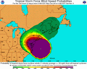
National Hurricane Center Hurricane Sandy Advisory No. 29A, 2 p.m. Oct. 29
Published 3:46 pm Monday, October 29, 2012
Bulletin
Hurricane sandy intermediate advisory number 29a
Nws national hurricane center miami fl al182012
200 pm edt mon oct 29 2012
…sandy moving more quickly toward southern new jersey…
…landfall expected early this evening…
Summary of 200 pm edt…1800 utc…information
———————————————-
Location…38.3n 73.1w
About 110 mi…180 km se of atlantic city new jersey
About 175 mi…285 km sse of new york city
Maximum sustained winds…90 mph…150 km/h
Present movement…nw or 305 degrees at 28 mph…44 km/h
Minimum central pressure…940 mb…27.76 inches
Watches and warnings
——————–
Changes with this advisory…
None
Summary of watches and warnings in effect…
A tropical storm warning is in effect for…
* north of surf city to duck north carolina
* pamlico and albemarle sounds
In addition…hurricane-force winds are expected along portions of
The coast between chincoteague virginia and chatham massachusetts.
This includes the tidal potomac from cobb island to smith point…
The middle and upper chesapeake bay…delaware bay…and the coasts
Of the northern delmarva peninsula…new jersey…the new york city
Area…long island…connecticut…and rhode island.
Tropical-storm-force winds are expected north of chatham to
Merrimack river massachusetts…the lower chesapeake bay…and
South of chincoteague to duck north carolina…the northern
Endpoint of the tropical storm warning.
Other coastal and inland watches and warnings are in effect for
These areas. Please see statements from local national weather
Service forecast offices.
For storm information specific to your area…including possible
Inland watches and warnings…please monitor products issued by
Your local national weather service forecast office.
Discussion and 48-hour outlook
——————————
At 200 pm edt…1800 utc…the center of hurricane sandy was located
By an air force reserve hurricane hunter aircraft and noaa doppler
Weather radars to be near latitude 38.3 north…longitude 73.1
West. Sandy is now moving toward the northwest near 28 mph…
44 km/h. This general motion is expected to continue through this
Afternoon and evening until landfall occurs…followed by a turn
Toward the west-northwest tonight. On the forecast track…the
Center of sandy is expected to make landfall along or just south of
The southern new jersey coast by early evening.
Reports from the hurricane hunter aircraft indicate that the maximum
Sustained winds remain near 90 mph…150 km/h…with higher gusts.
Sandy is expected to transition into a frontal or wintertime low
Pressure system later today or tonight. However…this transition
Will not be accompanied by a weakening of the system…and little
Change in strength is expected prior to landfall. Sandy is forecast
To weaken after moving well inland.
Hurricane-force winds extend outward up to 175 miles…280 km…
Mainly southwest of the center…and tropical-storm-force winds
Extend outward up to 485 miles…780 km. Sustained winds to
Tropical storm force are occurring from southern new england through
Long island and long island sound…and southward along the coasts
Of new jersey…delaware…and eastern virginia…and including all
Of the chesapeake and delaware bays. A weatherflow instrument
Recently reported a sustained wind of 54 mph…87 km/h…with a
Gust to 63 mph…102 km/h…on long island at eatons neck new york.
Also…a university of connecticut buoy located in western long
Island sound recently reported a sustained wind of 38 mph…61
Km/h…with a gust to 54 mph…87 km/h…at a height of 10 feet
Above the water.
The estimated minimum central pressure based on reports from
Reconnaissance aircraft is 940 mb…27.76 inches.
Hazards affecting land
———————-
Wind…gale/tropical storm force winds are already
Occurring over portions of the mid-atlantic states from north
Carolina northward to southern new england. Gale-force winds are
Expected to continue to spread over other portions of the
Mid-atlantic states over the next couple of hours.
Hurricane-force winds could reach the mid-atlantic states…
Including new york city and long island…by late this afternoon.
It is important to note that winds affecting the upper floors of
High-rise buildings will be significantly stronger than those near
Ground level.
Storm surge…the combination of an extremely dangerous storm surge
And the tide will cause normally dry areas near the coast to be
Flooded by rising waters. The water could reach the following
Depths above ground if the peak surge occurs at the time of high
Tide…
Nc north of surf city including pamlico/albemarle sounds…4 to 6 ft
Se va and delmarva including lower chesapeake bay…2 to 4 ft
Upper and middle chesapeake bay…1 to 3 ft
Long island sound…raritan bay…and new york harbor…6 to 11 ft
Elsewhere from ocean city md to the ct/ri border…4 to 8 ft
Ct/ri border to the south shore of cape cod including buzzards
Bay and narragansett bay…3 to 6 ft
Cape cod to the ma/nh border including cape cod bay…2 to 4 ft
Ma/nh border to the u.s./canada border…1 to 3 ft
Surge-related flooding depends on the relative timing of the surge
And the tidal cycle…and can vary greatly over short distances.
Given the large wind field associated with sandy…elevated water
Levels could span multiple tide cycles resulting in repeated and
Extended periods of coastal and bayside flooding. In addition…
Elevated waters could occur far removed from the center of sandy.
Furthermore…these conditions will occur regardless of whether
Sandy is a tropical or post-tropical cyclone. For information
Specific to your area…please see products issued by your local
National weather service office.
Rainfall…rainfall totals of 3 to 6 inches are expected over far
Northeastern north carolina with isolated maximum totals of 8
Inches possible. Rainfall amounts of 4 to 8 inches are expected
Over portions of the mid atlantic states…including the delmarva
Peninsula…with isolated maximum amounts of 12 inches possible.
Rainfall amounts of 1 to 3 inches with isolated maximum amounts of
5 inches are possible from the southern tier of new york state
Northeastward through new england.
Snowfall..snow accumulations of 2 to 3 feet are expected in the
Mountains of west virginia with locally higher totals today through
Wednesday. Snowfall of 1 to 2 feet is expected in the mountains of
Southwestern virginia to the kentucky border…with 12 to 18 inches
Of snow expected in the mountains near the north carolina/tennessee
Border and in the mountains of western maryland.
Surf…dangerous surf conditions will continue from florida through
New england for the next couple of days.
Next advisory
————-
Next complete advisory…500 pm edt.
Tropical cyclone updates will be issued at 300 and 400 pm edt.
$$
Forecaster stewart


