Prepare for Joaquin
Published 10:30 pm Wednesday, September 30, 2015
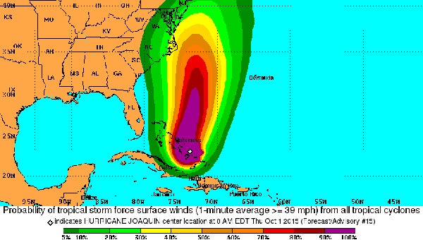
This graphic shows the probability of tropical storm-force winds hitting the East Coast within the next 120 hours. Suffolk was in the 30-percent stripe as of Thursday afternoon. (National Hurricane Center)
UPDATED Thursday 3 p.m.: Hurricane Joaquin has strengthened to a Category 4 storm.
UPDATED Thursday 2 p.m.: Gov. Terry McAuliffe is urging Virginians to prepare for a hurricane and its aftermath on the heels of an onslaught of heavy rain and flooding.
“We have a major weather pattern,” McAuliffe said during a news conference Thursday afternoon. “We will have flooding. We will see trees down. We will have power lost.”
Flooding already has been seen in the western part of the state, McAuliffe said, including nine roads washed away and 57 roads still closed.
“We do expect travel to become hazardous,” said Brian Moran, secretary of public safety and homeland security. “The main thing is to be safe and watch the ponding on the roadways.”
At 2 p.m. Thursday, Suffolk was under a coastal flood advisory and flood watch. A coastal flood watch is set to start Friday at 10 a.m. and last to Saturday at 6 p.m.
Rainfall amounts of four to seven inches are expected through Saturday. Ponding on roadways and flooding of low-lying and poor drainage areas is likely, especially where the ground is saturated, according to the National Weather Service. Stream and river levels also are expected to rise.
About 800 National Guard soldiers have been mobilized and will be pre-positioned across the state by the end of Friday.
The state officials said large-scale evacuations of coastal areas for Hurricane Joaquin are not planned, because the western areas of the state already are flooded.
UPDATED Thursday 12:10 a.m.: Joaquin is now a Category 3 storm.
Earlier: Rain will drench Suffolk and surrounding areas throughout the weekend with or without Hurricane Joaquin, a National Weather Service meteorologist says.
“The hurricane is still very, very uncertain,” said Bill Sammler. “Right now we have no confidence in exactly what’s going to happen with Joaquin past Friday night or Saturday morning.”
Joaquin, currently located east of Florida, is a Category 2 hurricane. Additional strengthening and a turn toward the northwest are expected in the next two days, according to the National Hurricane Center. Effects could be felt in Virginia near Sunday or Monday.
But before the hurricane even arrives — if it arrives — most of Virginia will be soaked to the gills, Sammler said.
“The one thing we can say for sure, regardless of what track Joaquin takes, is that we’re going to have a lot of rain across really all of Virginia through the weekend,” Sammler said. “We could have 5 to 10 inches of rain total between now and, say, Monday morning.”
The rain is coming from a front that’s expected to pass through the area on Wednesday and then stall just offshore, Sammler said. The front will then work its way back westward.
“It’s kind of a unique scenario, one that we don’t see too often,” Sammler said.
There is high potential for freshwater flooding, on the order of what occurred last weekend or possibly higher, Sammler said.
“Folks that live near the Nansemond River should watch the water levels,” he said. Folks should also beware of smaller creeks and streams that are susceptible to flooding.
Gov. Terry McAuliffe on Wednesday declared a state of emergency retroactive to Tuesday in response to the rain that has already taken place as well as the forecast.
The declaration activates the Virginia Emergency Operations Center and the Virginia Emergency Support Team, activates the Virginia National Guard and the Virginia Defense Force, permits evacuations if necessary and allows other actions needed to respond to the storm.