A look back at (and down on) Eclipse
Published 1:02 pm Thursday, November 19, 2015
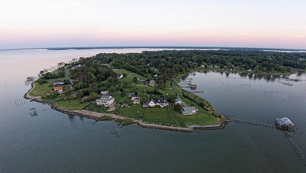
Photo by Phillip Long
To the editor:
On opening the September/October edition of Suffolk Living, I was elated to see the aerial view of Eclipse appearing on pages 4 and 5. I was born in 1929 in Eclipse and was raised there, and I spent many days in the environs of the area shown.
I would like to share some information about the picture that younger folks might not know.
The body of water shown on Page 5 is called “Hoe Cake Bay.” Numerous shanties stood along the shoreline for the non-resident oystermen who lived in them during oyster season. It seemed like they all made hoe cakes on their little stoves every day.
My mother said there were eight or 10 of these shanties there in the early 1900s. My uncle, R.L. Moger, had a small store there in about 1920.
The pier at the bottom of the photo is on the site of the old ferry dock built by Johnny Adams in about 1920. He had four ferry boats that ran daily to Newport News, carrying automobiles and passengers. Cars would line up on Dixon Road to board the ferry boats.
The old ferry dock was destroyed during the August 1933 storm. One large section floated across Hoe Cake Bay and lay on the shore near Bunkley’s dock for quite a few years.
The white building (upper right) is on the site of what was Bunkley’s Store. The old wooden structure was built in 1902 by S.Q. Bunkley and was a large country store that carried groceries of all kinds, meats, ice, marine supplies, clothing, shoes, hardware and more.
The pier remnants coming from the store supported two warehouses, three large gas tanks to service boats and a rail system on which a freight car could haul items back and forth. The old pier piles and some of the rails are still visible.
I have seen 10 to 12 boats docked there in the ‘30s and ‘40s, buying gas and oil, crackers, potted meat and cigarettes, which were two-for-a-penny at the store. Bunkley’s Store also held the Eclipse Post Office and was the gathering place for the community.
The old Barcalow house, shown in the upper center of the homes on Eclipse Drive, is the only remaining original house facing Hoe Cake Bay. My home is still there, but hidden in the trees behind the last white, two-story house at upper left.
The green area and trees in the foreground are on Pike’s Point, named for the man who owned most of the land in the photo. Mr. Pike was from Norfolk. He raised fennel on the upper hill, where several houses are now located.
The properties to the far left of the photo are on the bluff above what we called the River Shore. At one time, it had a good beach and swimming area. We had many good times there on picnics and swimming outings.
Many thanks to you and to Phillip Long for the fantastic aerial views.
W. Gene Corson