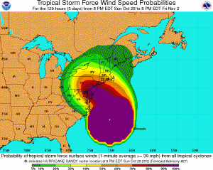
National Hurricane Center Hurricane Sandy Advisory No. 27, 11 p.m. Oct. 28
Published 11:25 pm Sunday, October 28, 2012
Bulletin
Hurricane sandy advisory number 27
Nws national hurricane center miami fl al182012
1100 pm edt sun oct 28 2012
…sandy about to start its northward turn…expected to bring
Life-threatening storm surge…coastal hurricane winds and heavy
Appalachian snows…
Summary of 1100 pm edt…0300 utc…information
———————————————–
Location…34.5n 70.5w
About 290 mi…465 km e of cape hatteras north carolina
About 470 mi…760 km sse of new york city
Maximum sustained winds…75 mph…120 km/h
Present movement…ne or 35 degrees at 14 mph…22 km/h
Minimum central pressure…950 mb…28.05 inches
Watches and warnings
——————–
Changes with this advisory…
None.
Summary of watches and warnings in effect…
A tropical storm warning is in effect for…
* north of surf city to duck north carolina
* pamlico and albemarle sounds
* bermuda
In addition…hurricane-force winds are expected along portions of
The coast between chincoteague virginia and chatham massachusetts.
This includes the tidal potomac from cobb island to smith point…
The middle and upper chesapeake bay…delaware bay…and the coasts
Of the northern delmarva peninsula…new jersey…the new york city
Area…long island…connecticut…and rhode island.
Tropical-storm-force winds are expected north of chatham to
Merrimack river massachusetts…the lower chesapeake bay…and
South of chincoteague to duck north carolina…the northern
Endpoint of the tropical storm warning.
Other coastal and inland watches and warnings are in effect for
These areas. Please see statements from local national weather
Service forecast offices.
For storm information specific to your area in the united
States…including possible inland watches and warnings…please
Monitor products issued by your local national weather service
Forecast office. For storm information specific to your area outside
The united states…please monitor products issued by your national
Meteorological service.
Discussion and 48-hour outlook
——————————
At 1100 pm edt…0300 utc…the center of hurricane sandy was
Located near latitude 34.5 north…longitude 70.5 west. Sandy is
Moving toward the northeast near 14 mph…22 km/h. A turn toward
The north is expected during the next several hours…with a turn
Toward the northwest expected on monday. On the forecast track…
The center of sandy will move over the coast of the mid-atlantic
States late monday or monday night.
Maximum sustained winds are near 75 mph…120 km/h…with higher
Gusts. Sandy is expected to transition into a frontal or wintertime
Low pressure system prior to landfall. However…this transition
Will not be accompanied by a weakening of the system…and in
Fact…a little strengthening is possible during this process.
Sandy is expected to weaken after moving inland.
Hurricane force winds extend outward up to 175 miles…
280 km…mainly to the southwest of the center…and tropical storm
Force winds extend outward up to 520 miles…835 km. A national
Ocean service station at the willoughby degaussing station near
Norfolk naval station virginia recently reported sustained winds of
45 mph…72 km/h…with a gust to 53 mph…85 km/h. A weatherflow
Station at thimble shoals virginia recently reported sustained
Winds of 44 mph…70 km/h…and a wind gust of 52 mph…83 km/h.
The minimum central pressure based on air force reserve and noaa
Hurricane hunter aircraft data is 950 mb…28.05 inches.
Hazards affecting land
———————-
Wind…tropical storm conditions are already occurring over coastal
North carolina and southeastern virginia. Gale force winds are
Expected to arrive along portions of the mid-atlantic coast later
Tonight…and reach long island and southern new england by monday
Morning. Winds of hurricane force could reach the mid-atlantic
States…including long island…on monday. Winds affecting the
Upper floors of high rise buildings will be significantly stronger
Than those near ground level.
Storm surge…the combination of an extremely dangerous storm surge
And the tide will cause normally dry areas near the coast to be
Flooded by rising waters. The water could reach the following
Depths above ground if the peak surge occurs at the time of high
Tide…
Nc north of surf city including pamlico/albemarle sounds…4 to 6 ft
Se va and delmarva including lower chesapeake bay…2 to 4 ft
Upper and middle chesapeake bay…1 to 3 ft
Long island sound…raritan bay…and new york harbor…6 to 11 ft
Elsewhere from ocean city md to the ct/ri border…4 to 8 ft
Ct/ri border to the south shore of cape cod including buzzards
Bay and narragansett bay…3 to 6 ft
Cape cod to the ma/nh border including cape cod bay…2 to 4 ft
Ma/nh border to the u. S./canada border…1 to 3 ft
Surge-related flooding depends on the relative timing of the surge
And the tidal cycle…and can vary greatly over short distances.
Given the large wind field associated with sandy…elevated water
Levels could span multiple tide cycles resulting in repeated and
Extended periods of coastal and bayside flooding. In addition…
Elevated waters could occur far removed from the center of sandy.
Furthermore…these conditions will occur regardless of whether
Sandy is a tropical or post-tropical cyclone. For information
Specific to your area…please see products issued by your local
National weather service office.
Rainfall…rainfall totals of 3 to 6 inches are expected over far
Northeastern north carolina with isolated maximum totals of 8
Inches possible. Rainfall amounts of 4 to 8 inches are expected
Over portions of the mid atlantic states…including the delmarva
Peninsula…with isolated maximum amounts of 12 inches possible.
Rainfall amounts of 1 to 3 inches with isolated maximum amounts
Of 5 inches are possible from the southern tier of new york state
Northeastward through new england.
Snowfall…snow accumulations of 2 to 3 feet are expected in the
Mountains of west virginia…with locally higher totals tonight
Through tuesday night. Snowfall of 1 to 2 feet is expected in
The mountains of southwestern virginia to the kentucky border…
With 12 to 18 inches of snow possible in the mountains near the
North carolina/tennessee border and in the mountains of western
Maryland.
Surf…dangerous surf conditions will continue from florida through
The mid-atlantic states for the next couple of days and spread into
The northeastern states later today.
Next advisory
————-
Next intermediate advisory…200 am edt.
Next complete advisory…500 am edt.
$$
Forecaster beven/roberts


