Capturing the James
Published 9:41 pm Monday, April 21, 2014
The James River Association and a Richmond-based company are about to set sail on a months-long project to create a Google Maps-type experience of the James River and tributaries.
Once the project is complete, online viewers will be able to travel up and down the river’s entire 340 miles on their computers, said Outside Ventures’ Andy Thompson.
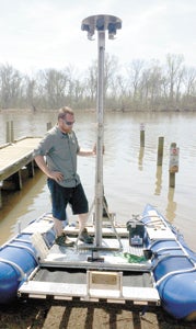
Ryan Abrahamsen is one of the future co-captains of a raft fitted with six cameras, upon which crews will travel the James to create a virtual tour of the river. They’ll even make into Suffolk waters, says Andy Thompson, another of those involved in the project.
“We’re excited,” he said. “We’ve been doing a lot of troubleshooting, and I think we will be getting under way in June.”
The aluminum-framed pontoon raft, specially built for the project, is outfitted with six Canon T2i cameras fitted with 8mm fisheye lenses.
The cameras are positioned on the boat in different directions atop a stainless steel housing 10 feet above the surface of the water. Each camera is angled at 60 degrees, Thompson said.
Thompson and Ryan Abrahamsen will take the small vessel through the tidal section of the James to the Chesapeake Bay, and another team will handle the Upper James.
Both teams will have ground support, according to Thompson. “Every three days we are going to get all the memory cards and give them new memory cards,” he said.
The teams will camp, according to Thompson, at private and state park campgrounds, on islands within the river, and on private land whose owners JRA has a relationship with.
A solar panel will power the trolling motor that will be used during the first section, and a 45-horsepower gas engine will take over in the tidal James, Thompson said.
“We are going to do the tidal section twice,” he said. “The river is so wide, there is no real point in just going down the middle.”
The goal, Johnson said, is to also photograph “all the major tributaries.” Though those details were being ironed out, he added, it would include the Nansemond River and a couple of other Suffolk waterways.
How much data will be collected? More than three terabytes and more than 360,000 photographs, Thompson said.
While the raft is in motion, shutters on the cameras will open every 30 feet, he said. Using custom software, and utilizing global positioning technology, they’ll be stitched together to create what a news release describes as “a 360-degree augmented reality map of the river corridor.”
The final, interactive online experience will also highlight natural, recreational and historic features, like major rapids, boat ramps and Civil War sites, according to Thompson.
The project is part of Envision James, and collaboration between National Geographic, the Chesapeake Conversancy and the James River Association.
More News


SportsPlus
How to Watch the Orioles vs. Padres Game: Streaming & TV Channel Info for July 27
Michael King will look to shut down Gunnar Henderson and the Baltimore Orioles when they play his San…
How to Watch MLB Baseball on Friday, July 26: TV Channel, Live Streaming, Start Times
Today’s MLB slate has plenty of excitement, including the matchup between the Cleveland Guardians and the Philadelphia Phillies.…
How to Watch the Orioles vs. Padres Game: Streaming & TV Channel Info for July 26
Gunnar Henderson and the Baltimore Orioles will meet Jurickson Profar and the San Diego Padres on Friday at…
Orioles vs. Padres: Betting Preview for July 26
In the series opener on Friday, July 26, Gunnar Henderson and the Baltimore Orioles (61-41) take on Jurickson…
Washington Commanders vs. Chicago Bears Week 8 Tickets Available – Sunday, October 27 at Commanders Field
On Sunday, October 27, 2024, the Chicago Bears (0-0) take on the Washington Commanders (0-0) at Commanders Field.…
