VDOT talks Route 460 safety
Published 9:11 pm Tuesday, October 24, 2017
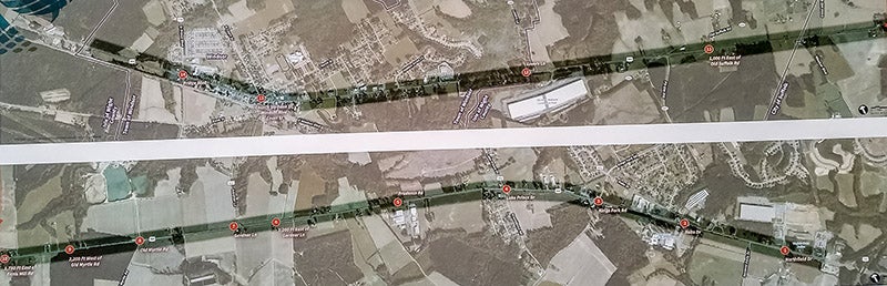
- This map shows Route 460 and intersections that VDOT is studying for safety concerns. The top map shows the town of Windsor. The bottom map shows the city of Suffolk. Stephen Faleski
Stephen Faleski
Special to the News-Herald
Residents of Windsor and the surrounding areas of Isle of Wight along the Route 460 corridor took advantage of an opportunity to air their safety concerns regarding the highway on Thursday evening.
Virginia Department of Transportation representatives held a public meeting at Windsor High School to present the preliminary results of their safety and operations study of the corridor.
The two-phase safety assessment is still under way, evaluating the corridor from Windsor’s western limits near Lover’s Lane to 1,500 feet west of the U.S. 58 interchange in Suffolk.
“The purpose of this meeting is to get feedback from the locals,” said Jerry Pauley, transportation planning engineer for VDOT’s Hampton Roads District. “They’re on this road every day.”
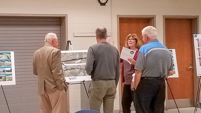
Residents of Isle of Wight County bordering Route 460 examine maps showing the areas of the highway that VDOT is now studying for safety concerns.
Stephen Faleski
The objective of the safety assessment, he said, is to identify lower-cost measures that could be implemented at hot spots and along the corridor within the existing right of way.
The study began with a request from the municipal governments of Isle of Wight and the Suffolk for VDOT to examine what could be done to improve the existing road, now that the Route 460 bypass plans have been scrapped.
“We’re going to make a number of recommendations,” Pauley said. “Some of these recommendations, VDOT will be taking care of, like signage, road markings. The larger projects — like adding the turn lanes — we will give the information to the localities, and they would submit that to the Smart Scale program for funding.”
“If it is a chosen project, it would be 100 percent funded with VDOT money allocated for 2023” he added. “Although we would be going for the 2023 money, there are some possibilities it could go sooner.”
Attendees were asked to choose their top three priorities from a list of 14 problem intersections and stretches of road on Route 460 that VDOT has studied.
Those intersections included Northfield Drive, Robs Drive, Kings Fork Road, Lake Prince Drive, Prudence Road, 1,200 feet east of Gardner Lane, Gardner Lane, Old Myrtle Road, 2,200 feet west of Old Myrtle Road, 1,750 feet east of Ennis Mill Road, 1,000 feet east of Old Suffolk Road, Lovers Lane; Church Street, Bank Street, Windsor Boulevard and Court Street as one area; and Prince Boulevard (Route 258).
VDOT representatives said that given the scope of what they are now investigating and the amount of funding available, a majority of their recommended improvements to the road will likely not be in Windsor, nor will they include widening the existing highway due to right-of-way concerns. That means the town’s desire for a center turn lane will likely be unmet.
“To even consider doing a center turn lane, you have to look at things like drainage, utilities, sidewalks, so your right of way would be expanding no matter what,” Pauley said. “We’re not even looking in the town, because we’re looking at these low-cost improvements.
“There were several crashes within the town, but most were property-damage style crashes,” he added.
Noting a series of sketches that plotted accident types and locations along Route 460, Pauley said, “We’re concentrating on the sections outside of town where the crashes have resulted in the most injuries so we can get the most bang for our buck.”
More News


SportsPlus
Vikings, Lions, Week 8 NFL Power Rankings
Seeking an updated view of the NFL and how each team stacks up? We’ve got you covered below,…
Buy Tickets for Philadelphia Flyers vs. Washington Capitals on October 22
The Philadelphia Flyers and Washington Capitals hit the ice at Wells Fargo Center on Tuesday, October 22 at…
Discover the Best Week 8 NFL Player Prop Bets & Odds
The Week 8 NFL lineup has several top-tier games, including the matchup between the Minnesota Vikings and the…
Wizards vs. Warriors Tickets Available – Monday, Nov. 4
The Washington Wizards have a matchup against the Golden State Warriors on Monday, November 4, 2024 at 7:15…
Dylan Strome Player Prop Bets for the Capitals vs. Flyers Game – October 22
Dylan Strome will be on the ice when the Washington Capitals and Philadelphia Flyers play at Wells Fargo…
