The latest on Florence
Published 6:36 pm Saturday, September 8, 2018
NOAA: Florence on track for Carolina coast
Sept. 12, 5:20 p.m.
The track for Hurricane Florence remains set for the coastlines of North Carolina and South Carolina, and further movement south keeps projections relatively positive for Virginia residents, the National Hurricane Center reports.
According to the latest Wednesday update at 5 p.m., Hurricane Florence is about 385 miles southeast of Wilmington, N.C. and about 420 miles east-southeast of Myrtle Beach, S.C. The storm is moving northwest at 16 mph with maximum sustained winds of 120 mph.
This general motion – accompanied by a gradual decrease in forward speed – is expected through Saturday. The center of Hurricane Florence is forecasted to move over the southwestern Atlantic Ocean between Bermuda and the Bahamas on Wednesday, then approach the coast of North Carolina or South Carolina on Thursday and Friday. The storm will then move slowly near the coastline on Saturday, the National Hurricane Center reports.
Hurricane Florence has dropped from a category four hurricane to a category three hurricane and maximum sustained winds have decreased to near 120 mph, although some fluctuations in strength will be possible through Thursday morning. The National Hurricane Center reports that Florence has hurricane-force winds extending outward up to 70 miles from its center and tropical-storm-force winds that extend outward up to 195 miles, as of the 5 p.m. update.
Florence is expected to slow down considerably after approaching the North Carolina coast on Thursday, then turn westward with a very slow westward motion near the coasts of North Carolina and South Carolina on Friday and Saturday.
No significant changes were required to the previous advisory track, which still shows Florence moving slowly westward across South Carolina and western North Carolina on Sunday, followed by a northward motion up the Appalachian mountain chain on Monday, the National Hurricane Center reports.
According to the National Oceanic and Atmospheric Administration, Hampton Roads is now projected to receive between two-to-four and four-to-six inches of rainfall and wind speeds between 30-to-40 and 40-to-50 in certain areas.
National Weather Service Meteorologist Mike Rusnak said the forecast has remained consistent for Hampton Roads for the past 12 hours. The storm will make landfall on the South Carolina and North Carolina coastlines and drift south, but while the main effects of the storm will be south of Virginia, residents in Hampton Roads are still facing tropical storm weather.
“It’s still going to be pretty stormy in Hampton Roads, with moderate-to-heavy rain starting (Thursday) afternoon,” Rusnak said on Wednesday evening. Total rainfall is expected to be between three-to-five inches and wind gusts between 30-to-40 mph starting late-Thursday evening into Friday evening. “It’s not as bad as it appeared to be a couple of days ago, but it’s still going to be pretty stormy.”
The next intermediate update is expected at about 8 p.m. and the next complete advisory at about 11 p.m. on Wednesday. Visit nhc.noaa.gov for more information.
NOAA: Hurricane projections slightly improve
Sept. 12: 12:01 p.m.
The projections for Hurricane Florence have improved for Hampton Roads, but there is still reason to be cautious and prepared before landfall later this week, the National Hurricane Center reports.
According to the latest Wednesday update at 11 a.m., Hurricane Florence is about 485 miles southeast of Wilmington, N.C. and about 520 miles east-southeast of Myrtle Beach, S.C. The storm is moving northwest at 15 mph with maximum sustained winds of 130 mph.
This general motion – accompanied by a gradual decrease in forward speed – is expected through Saturday. The center of Hurricane Florence is forecasted to move over the southwestern Atlantic Ocean between Bermuda and the Bahamas on Wednesday, then approach the coast of North Carolina or South Carolina on Thursday and Friday. The storm will move slowly near the coastline on Saturday, the National Hurricane Center reports.
Florence is a category four hurricane that’s expected to strengthen Wednesday night. While some weakening is expected to begin by late-Thursday evening, the storm is still expected to be extremely dangerous when it nears the coast on Friday, with hurricane-force winds extending outward up to 70 miles from the Florence’s center and tropical-storm-force winds extending outward up to 175 miles.
“The threat to life from storm surge and rainfall will not diminish, and these impacts will cover a large area regardless of exactly where the center of Florence moves,” the National Hurricane Center reports.
According to the National Oceanic and Atmospheric Administration, Hampton Roads is now projected to receive four-to-six inches of rainfall and wind speeds between 30-to-40 and 40-to-50 in different areas.
National Weather Service Meteorologist Bridget De Rosa said that the forecast for rain is roughly 2.25 inches in northern Suffolk and about 2.75 inches in downtown Suffolk and the southern edge of the county for Friday night and into Saturday morning.
Wind speeds in Suffolk are expected to pick up on Thursday between 20-to-25 mph, with strongest winds projected for Friday night around 40-to-45 mph going into Saturday morning.
Rainfall and wind speeds are expected to begin gradually tapering off on Saturday, De Rosa said.
“We’re just waiting for the next round of models to come in,” she said Wednesday morning. “There’s still room for things to slightly improve for the area.”
The next intermediate update is expected at about 2 p.m. and the next complete advisory at 5 p.m. on Wednesday. Visit nhc.noaa.gov for more information.
NOAA: Florence stays on track
Sept. 11: 5:30 p.m.
The National Hurricane Center is reporting that Florence is mostly remaining on its previously reported track, with only minor track shifts to the west.
But all global and regional models are indicating that steering currents will collapse within 72 hours when Hurricane Florence approaches the southeast coast, and with weak steering currents expected to continue throughout the weekend, which makes the forecast track for Friday through Sunday “quite uncertain,” according to the latest update at 5 p.m.
Hurricane Florence is about 360 miles south-southwest of Bermuda and about 785 miles east-southeast of Cape Fear, N.C., with maximum sustained winds of 140 mph. It’s moving west-northwest at 17 mph.
A motion toward the west-northwest and northwest is expected through early Thursday, the National Hurricane Center reports, and Florence is expected to slow down “considerably” by late Thursday evening and into Friday morning.
Florence is forecasted to move over the southwestern Atlantic Ocean between Bermuda and the Bahamas through Wednesday and approach the hurricane warning area on the coast of North Carolina or South Carolina on Thursday and Friday.
Florence is a category 4 hurricane that’s expected to strengthen Tuesday evening and Wednesday. While some weakening is expected on Thursday, the National Hurricane Center reports, Florence is still forecast to be an extremely dangerous major hurricane through landfall, with hurricane-force winds that extend outward up to 60 miles from the Florence’s center and tropical-storm-force winds extending outward up to 175 miles
The National Hurricane Center reports that Florence is expected to produce total rainfall accumulations of 15-to-25 inches with isolated maximum amounts of 35 inches over portions of the Carolinas and Mid-Atlantic States from later this week and into early next week. This rainfall would produce catastrophic flash flooding and significant river flooding.
“Winds are expected to first reach tropical storm strength on Thursday, making outside preparations difficult or dangerous,” the National Hurricane Center reports. “Preparations to protect life and property should be rushed to completion.”
According to the National Oceanic and Atmospheric Administration, Hampton Roads is projected to receive six-to-10 inches of rainfall and wind speeds of 60-to-70 miles per hour during the storm.
National Weather Service Meteorologist Mike Rusnak said they expect the storm to ramp up in Suffolk Thursday evening and Friday morning, when Florence is expected to make landfall on the coast. He said that the forecast for Suffolk has improved because the storm is expected to stall on the North Carolina coast.
“It’s still going to be five to eight inches of rain potentially, but not like the 15 inches it looked like yesterday,” he said for Suffolk’s forecast.
The next intermediate update is expected at about 8 p.m. and the next complete advisory at 11 p.m. on Tuesday. Visit nhc.noaa.gov for more information.
NOAA: Hurricane Florence has ‘rapidly intensified’
Sept. 10, 6:49 p.m.:
The National Hurricane Center is reporting that Florence has rapidly intensified into “an extremely dangerous hurricane,” but has not yet peaked in its intensity. Hurricane Florence is expected to intensify close to category five strength on Tuesday, supported by a continuation of a low-shear environment and warmer waters over the next 36 hours.
Hurricane Florence is about 525 miles south-southeast of Bermuda and about 1,170 miles east-southeast of Cape Fear, N.C., with maximum sustained winds of 140 mph, according to the latest update at 5 p.m. It’s moving west-northwest at nearly 13 mph.
It’s expected to increase in forward speed in the next few days, the National Hurricane Center reports, and a turn toward the northwest is forecast to occur late Wednesday evening. The center of the hurricane is expected to approach the coast of South Carolina or North Carolina on Thursday.
Florence is a category four hurricane that’s anticipated to strengthen to be “an extremely dangerous major hurricane” through Thursday, the National Hurricane Center reports. Hurricane-force winds extend outward up to 40 miles from hurricane’s center, and tropical-storm-force winds extend outward up to 150 miles.
“While the intensity forecast shows some weakening of the maximum winds near landfall, the wind field is expected to grow with time, which increases the storm surge and inland wind threats,” the National Hurricane Center reports. “The bottom line is that there is high confidence that Florence will be a large and extremely dangerous hurricane, regardless of its exact intensity.”
According to the National Oceanic and Atmospheric Administration, Hampton Roads is projected to face six-to-10 inches of rainfall and wind speeds of 60-to-70 miles per hour during the storm.
National Weather Service Meteorologist Mike Rusnak said they expect the storm to ramp up in Suffolk Thursday evening – with the hurricane making landfall on the coast that day – and into Friday morning.
The next update is expected at about 11 p.m. on Monday. Visit nhc.noaa.gov for more information.
NOAA: Hurricane Florence ‘large and extremely dangerous’
Sept. 10, 12:57 p.m.: The National Hurricane Center is reporting that Florence has strengthened on Monday to a “large and extremely dangerous hurricane” that’s on track to hit the southeastern United States.
Hurricane Florence is about 580 miles south-southeast of Bermuda and about 1,240 miles east-southeast of Cape Fear, N.C., with maximum sustained winds of 115 mph, according to the latest update. It’s moving west at nearly 13 mph, the National Hurricane Center reports, and a west-northwestward motion is expected over the next few days with an increase in forward speed.
A turn toward the northwest is forecasted for Wednesday evening. Hurricane Florence’s center will approach the coast of South Carolina or North Carolina on Thursday. Hurricane-force winds extend outward up to 30 miles from the center and tropical storm-force-winds extend outward up to 140 miles.
Florence is also moving over progressively warmer waters over the next few days, with warmer temperatures peaking near 85-degrees. Models show that Florence should continue to strengthen and become a category four hurricane by Tuesday.
There will likely be fluctuations in intensity from eyewall cycles, the National Hurricane Center reports, but the hurricane’s wind field is still expected to grow over time. This will increase the storm surge and inland wind threats.
“The bottom line is that there is increasing confidence that Florence will be a large and extremely dangerous hurricane, regardless of its exact intensity,” the report states.
National Weather Service Meteorologist Mike Montefusco confirmed that this latest forecast update is in line with recent updates for Hurricane Florence from the National Hurricane Center. The next update is expected at about 5 p.m. on Monday. Visit nhc.noaa.gov for more information.
Governor: Virginians should prepare now
Sept. 9, 11:20 p.m.: Virginia Department of Emergency Management teams have worked throughout the weekend preparing for what may be Virginia’s most significant hurricane event in decades. With Virginia under a state of emergency, and forecasts showing Florence zeroing in on the Mid-Atlantic, the time for all Virginians to prepare is now.
While it is too soon to know the exact track that Hurricane Florence will take, the majority of forecast models are indicating significant potential impacts to Virginia in the form of coastal storm surge, catastrophic inland flooding, high winds and possible widespread power outages.
Virginia emergency managers and first responders are already mobilizing to prepare for the storm. Gov. Ralph Northam declared a state of emergency late Saturday in order to mobilize personnel and resources for storm impacts, and to speed the response to those communities that are damaged by the storm. This includes resources from Virginia Department of Emergency Management, the Virginia Department of Transportation, Virginia State Police, Virginia Department of Health, Virginia National Guard and others.
All Virginians should expect potential impacts and life-threatening conditions from this storm. Now is the time to prepare. To learn more, visit www.VAEmergency.gov/hurricanes.
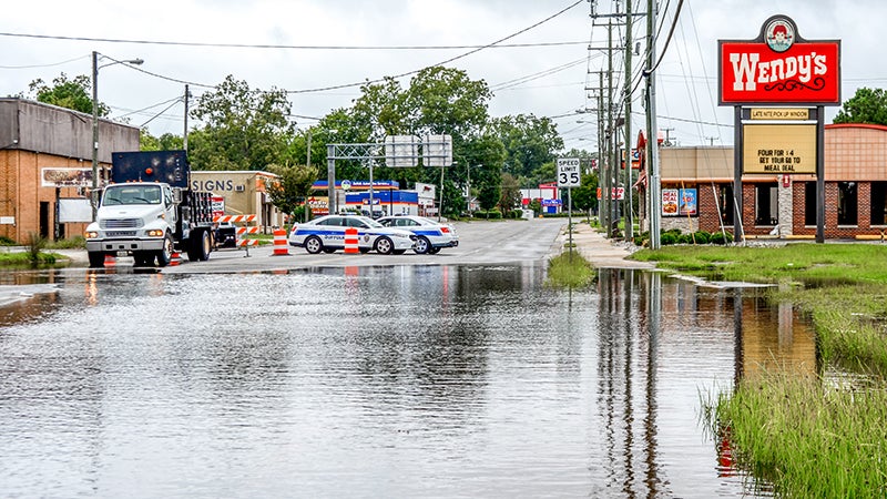
The largest threat to life from hurricanes is not the high winds. Flooding is the deadliest result of these storms.
Current forecast models indicate that Florence could strike the Carolinas and enter Virginia, possibly stalling and dropping more than 20 inches of rain in some areas. This will lead to widespread and dangerous flooding, inundation of roads and damaged infrastructure. Potential widespread power outages are also expected.
Citizens should prepare for rising waters, flash flooding, and remember never to drive across flooded roadways. Most injuries and deaths occur when motorists try to cross flooded roads. Roads and bridges can be damaged or completely washed away beneath flood waters, and a few inches of water can sweep vehicles downstream. Remember, turn around, don’t drown.
Residents in Coastal Virginia, especially those in evacuation zones A and B, should begin preparing for potential evacuation. An evacuation decision will be made Monday, Sept. 10. If ordered, instructions about evacuation will be communicated via social media, television, radio, newspapers and through local and state emergency management websites.
Citizens should make necessary preparations now to evacuate to higher ground, starting with knowing in which zone your home and business are located. You can type in your address at www.KnowYourZoneVA.org to find out your designated zone. Resources are also available on the Know Your Zone website to learn more about the program, what to plan for and expect in the event of an evacuation, and how to ensure you are ready once you receive evacuation instructions.
Once you Know Your Zone, you should stay tuned to local media for detailed instructions from your local emergency manager about where to go, available shelters and evacuation routes, and when you will be able to return to your home.
With the onset of tropical storm force winds and rain only a couple of days away, the time to prepare is now. Get your home, business and family ready for whatever impacts this storm may bring. Hurricane season lasts through Nov. 30, so more storms may target Virginia this year.
Visit http://www.vaemergency.gov/hurricanes to learn how to prepare for these deadly storms. It could save your life.
Governor declares state of emergency
Sept. 8, 6:35 p.m.: Gov. Ralph Northam declared a state of emergency Saturday in anticipation of the potential impact from Tropical Storm Florence.
The order is designed to mobilize resources in preparations of the storm, according to a press release from the governor’s office. It also is meant to help mitigate any damage and to streamline the process that the state uses to provide assistance to other states vulnerable to Florence.
“While the impacts of Tropical Storm Florence to Virginia are still uncertain, forecasts increasingly expect the storm to strengthen into a major hurricane that could seriously affect the East Coast and Virginians,” Northam said. “Accordingly, I am declaring a state of emergency so that we can begin to prepare state assets, and I encourage Virginians to monitor forecasts and make their own preparations now.”
A state of emergency allows the commonwealth to mobilize resources, including the Virginia National Guard, and pre-position people and equipment to assist in storm response and recovery efforts.
While the track of Tropical Storm Florence is still uncertain, it appears increasingly likely that Virginia may see significant impacts from this storm next week. Impacts include possible flooding, high winds, and potential storm surge.
The Governor’s Office, the Virginia Department of Emergency Management, the Federal Emergency Management Agency, the Virginia National Guard, the Virginia State Police and other state agencies have already begun preparations for the impacts of Tropical Storm Florence.
State agencies are working closely with localities to identify any needs in advance of the storm, and to pre-position resources where they will be most effective. The state Emergency Operations Center will be staffed next week in preparation for the storm and will transition into 24/7 operations as needed when the storm approaches, according to the release.
Due to the uncertainty of the storm’s track this many days in advance, the Virginia Department of Emergency Management encourages all residents to prepare for impacts from this storm. These can range from high winds and storm surge in coastal Virginia to significant flooding both along the coast and in rivers and streams in the western part of the state. Citizens should remember that flash floods could happen at any time and that flooding is the most deadly and damaging part of any hurricane.
Virginians should remember to “turn around and don’t drown.” Do not drive across any flooded roadway, as it takes only 6 inches of water to move a vehicle and roads may be washed out beneath the floodwaters.
In advance of the storm, assemble your emergency kit including food, water, medications, pet supplies and important documents that you will need to take with you if asked to evacuate in short order. To learn more about what to include in your emergency kit and how to prepare for hurricanes, visit www.VAemergency.gov/hurricanes.
It is also important for residents of Coastal Virginia to “Know Your Zone” before this storm impacts Virginia. If you live in Hampton Roads, the Middle Peninsula, Northern Neck or Eastern Shore, learn which new hurricane evacuation zone you live in by visiting www.KnowYourZoneVA.org.
Stay tuned to local media in the coming days to keep close tabs on Hurricane Florence as it approaches the state. Be prepared to take action, and know that storm forecast can vary significantly over just a few hours.
More Hurricane Stories

SportsPlus
How to Watch MLB Baseball on Friday, July 26: TV Channel, Live Streaming, Start Times
Today’s MLB slate has plenty of excitement, including the matchup between the Cleveland Guardians and the Philadelphia Phillies.…
How to Watch the Orioles vs. Padres Game: Streaming & TV Channel Info for July 26
Gunnar Henderson and the Baltimore Orioles will meet Jurickson Profar and the San Diego Padres on Friday at…
Orioles vs. Padres: Betting Preview for July 26
In the series opener on Friday, July 26, Gunnar Henderson and the Baltimore Orioles (61-41) take on Jurickson…
Washington Commanders vs. Chicago Bears Week 8 Tickets Available – Sunday, October 27 at Commanders Field
On Sunday, October 27, 2024, the Chicago Bears (0-0) take on the Washington Commanders (0-0) at Commanders Field.…
Washington Commanders vs. Cleveland Browns Week 5 Tickets Available – Sunday, October 6 at Commanders Field
Sunday, October 6, 2024 will see the Cleveland Browns (0-0) hit the road to match up against the…
